SEG field camp 2020
SEG Field Camp 2020 – Geophysical imaging of dissolution phenomena in porous carbonate media (inactive Smerdyna quarry, Poland)
1. The SEG mission in our field camp project
As members of the SEG student society, we would like to drive the SEG's mission of gathering people further to be something bigger, geophysical society, and improving skills of students with the knowledge at different levels. During this project, we would like to raise awareness not only of students but also of the authorities and local people about geophysical methods, what they give, and why they are useful for them. To create a more mature and complete fieldwork team, we address our camp for people with different expertise, from beginners through experienced students to real scientists as our lecturers. Thanks to that, we get a real society in which everything is possible, and each person can find the place. This event can be an inspiration not only for young but also for scientists, cause they can refresh their minds and find joy in working together with adepts of geophysics.
Because we live in a worldwide society, the participants should be from different nations. SEG's mission and ours are not to divide the geophysical society. We live on the same planet, so our beliefs, cultures, and views cannot be a reason for isolation and divisions. That kind of approach has a lot of benefits, especially the possibility of improving language proficiency and co-working skills. It also makes us more open to people and new ideas. By working with this philosophy, our members and project board will be more diverse, complete, and international.
During fieldwork, we will conduct measurements by using a multitude of geophysical methods to get hands-on experience in different aspects of geophysics, which should be beneficial for the future career paths of the project participants.
2. Description of the area
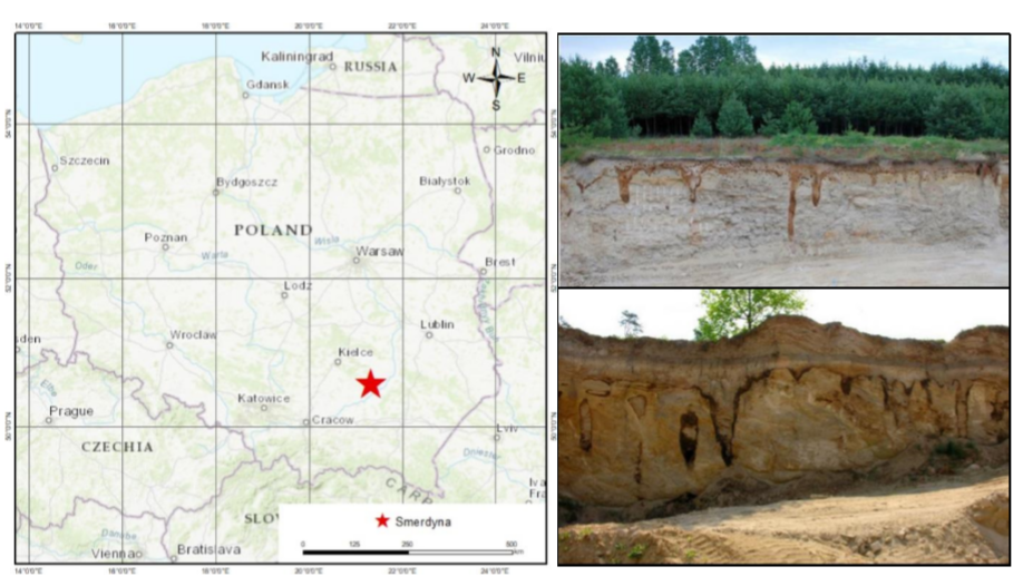
Our field work site is located near Smerdyna – in the SE rim of the Holy Cross Mts. Smerdyna is famous for its sandstone and limestone quarries. The village is located about 18 km from Staszów and about 40 km from Sandomierz (Fig. 1). It was founded in the XII century as a settlement of Smerds. The name of the place probably comes from them (Smerd - a medieval term for a group of people with low social status). The limestone mined here has a grainy structure and is fragile and soft immediately after extraction, and can be cut with a wood saw. It exhibits high porosity and absorbency, is a sought-after building material. Stone from this quarry was used as a building material in the vicinity of Staszów and Sandomierz. Currently, it mainly serves as a decorative material. Smerdyna is worth seeing for the interesting landscape created as a result of exploitation. In the rock walls, you can find shells and traces of the ancient sea. The most interesting feature of the limestones from Smerdyna is the development of the meter-scale solution pipes (dissolution patterns, aka wormholes) (Fig. 1). Their geophysical characterization is the main objective of this project for the interesting landscape created as a result of exploitation. In the rock walls, you can find shells and traces of the ancient sea.

Fig.1. A red star marks the location of the study region on the map of Poland. Solution pipes in the limestone quarry at Smerdyna.
The main aim of this field camp will be to find and localize the solution pipes (dissolution patterns, aka Wormholes, Fig.1) in limestone, characteristic for this quarry. These pipes are formed in the limestone bedrock. They are postulated to have been formed by a dissolving action of CO2 enriched water during Elsterian deglaciation. This CO2 enriched water can dissolve the pore matrix of the rocks and can create these wide channels which are visible at the wall of the quarry, are also known as wormholes. The brown rims in the clay filling the pipes are the result of clay and iron oxide accumulation due to the illuviation processes. The clay particles are transferred by water from the upper parts of the soil and then flocculated at the clay-limestone boundary, where the pH changes from mildly acidic to alkaline. However, most of the studies in this quarry has been done based on the data collected from these visible wormholes on the walls. We propose to study the quarry for a more detailed image of geological structures by collecting field data form geophysical methods.
3. Geophysical Methods
To achieve this goal, we plan to use very shallow geophysical methods:
● Ground Conductivity Meter (GCM) and ERT (Electrical Resistivity Tomography) - Occurrence of searched pipes is associated with contrast in electrical conductivity/resistivity. Limestone bedrock is rather weakly conductive, in the opposite of ironic clay. ● Ground Penetrating Radar (GPR) - The dielectric constant contrast should be observable between bedrock and the filling medium. Searched dissolution patterns should be marked as areas with significantly worse electromagnetic wave spread.
● Gradient Magnetometry - Due to the high content of iron in the filling medium, the magnetic effect should be noticeable. It should be remembered that we are talking about shallow, surface structures, which should facilitate the task of this method. ● Multichannel Analysis of Surface Waves (MASW) - there should be a contrast between shear velocity. MASW will be useful for finding saturated layers and shallow structures. The obtained Vs model after recalculation will be an initial model for seismic tomography.
A minor goal will be examining the basement of the quarry and the examination of possible rock relaxation in the quarry walls. For this purpose, we propose to conduct deeper some deeper measurements:
● Seismic (seismic tomography and seismic imaging) - there should be a contrast between velocity (Vp) of clay and limestone. Applying different seismic methods gives a more complex image of investigated structures. Seismic tomography, which has a larger depth of penetration compared to MASW, and gives Vp field useful for NMO correction and time to depth conversion in seismic imaging. The seismic imaging result will show structures with high resolution and also provide information about deeper geology. ● ERT with different (wider) geometry - was mentioned in the previous paragraph, ● Audio-magnetotelluric (AMT) - A good closing would be to carry out several soundings to determine the distribution of electrical conductivity in a deeper substrate.
Full and proper geophysical characterization of this area might help to understand the dissolution process and physical conditions of the formation of wormholes. Moreover, this work may prevent rockfall or other mass movements, caused by karst phenomena in limestones. We provide all the necessary equipment which is available in our Institute.
4. Outcomes
The main objective of our field camp is the education of students and local society. Thanks to the group of experienced geophysicists (Ph.D. students), this project is a great opportunity to improve teaching and leadership skills. All participants will gain the on-hand experience essential to conduct geophysical surveys by themselves and they check the understanding of methods in practice. Hopefully, it will be visible in the GPAs of students. The scientific outcome will be a complex geological image of the dissolution pattern in the rock body created by combining all results from different geophysical methods. Careful processing and interpretation should lead to valuable conclusions. We want to publish our results both in geophysicsoriented journals, as well as in more popular ones (like TLE), to be able to reach out to a wider audience. Of course, we will share our knowledge with the local community and authorities to help them understand how geophysics can be used in mitigating natural hazards (e.g., rockfall) or land use. As a continuation of the project, the outside participants will be encouraged to do an internship at our Institute.


